| Upcoming Events |
| Thursday Night Paddle
Thursday Night Hingham Harbor trips for 2019 will begin on April 25. See you then! |
| Thursday Skills Sessions
Skills Sessions for 2019 will begin on May 16. |
Mission Statement — The Wild Turkey Paddlers is an informal group of people interested in flatwater and ocean paddling.
Our purpose is to help kayak and canoe enthusiasts find others with whom they can paddle and learn more about the sport.
We hope to create awareness of proper paddling safety, promote a greater appreciation of the waterways of Southeastern Massachusetts and provide valuable and sometimes hard to find information about paddling in the area.
But most of all, we just want to paddle, meet people and have fun.
We would truly like to benefit from your experience. Have a favorite place to paddle? Let us know about it. Tell us where it is, how to get to it, where the put-ins/take-outs are, and anything the paddler should be aware of.
Contact us via: admin@wtpaddlers.org. Include "kayak" or "paddle" somewhere in the subject line to bypass the spam filter.
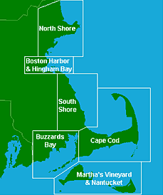
| Tide Charts Click on a segment of the map for that region's tide chart index. |
|
|
Monomoy - Trip report by Briggsy
We launched at 9am into a mirror calm Stage Harbor, it was HOT already, the forecast being in the 90's for the day. High tide was 5.52am so we got a nice push out of Stage Harbor and turned East towards what I believe they call the "South way".
I had never been round Morris Island to the Causeway so we went there first to check out an alternate put-in location. The heat finally got to Barb and she went in for a cooling dip in the harbor.
From there we headed south keeping the barrier beach close to our left. Other than a few noisy powerboats conditions were perfect, barely a ripple on the water. Our aim was the southern most point of the "South way" where it used to be possible to pass through a channel that led to the Atlantic. Sand now blocks the route but 2 guys in a small powerboat obviously thought it still existed. They stopped to ask if we knew where the channel was. I told them it was blocked and they said they went through it last week but couldn't find it today. Hmmmm. Unconvinced they buzzed off again in search of the elusive channel. Maybe after Hurricane Earl this weekend it will open again!!
About 11.30 we finally arrived at the blocked channel. Low tide was 11.45 so we hauled our boats way up onto the beach. We walked about 5 minutes to the Atlantic side over the "Land bridge" that now connects Monomoy Island to the mainland. You could see where the channel once went through. We were greeted by seals a few yards offshore who were enjoying the light surf, it looked so inviting in the heat that we all jumped in. Now how far away from seals were we supposed to be keeping bearing in mind the recent Great White sightings???....ah yes I think it was 30 yds, so we were OK.
Random notes...
The furthest inland navigable point on the North River is at the Hanover launch, located in Massachusetts. Directions: Pass Bldg #19 as you travel north on Rt 53. Left at the lights (West Elm St.), bear left to stay on W. Elm, left on Indian Head Dr. (just before crossing river), parking at end of road on right. Technically, this is the Indian Head River at this point. About a half-mile downstream, it joins with Herring Brook, where you can kayak, and becomes the North River where you can paddle or canoe in mass. Towards high tide, you can navigate quite a way up Herring brook. None of this is atlantic ocean or sea kayaking.
The Cohasset coastline is one of the more beautiful sections of real estate on the South Shore. Obscenely expensive homes occupy virtually all of the rocky shore in this tiny Massachusetts town. And in a relatively small area, there can be found kayaking for flatwater, whitewater and ocean kayakers alike.
The Gulf River is a tidal estuary that feeds from the harbor. This can be a very dangerous area, because with the exception of short periods of time during the tide schedule, the current is very fast and is flowing over boulders. This area is quite popular with whitewater paddlers - you can often find them paddling in place among these rapids.
Plymouth Harbor also offers a nice launch point for a kayaking trip to Saquish, Gurnet Light and Clarks Island, all located in Massachusetts. This would be a higher level trip requiring appropriate skills and equipment. Again, be aware of channels, boat traffic and current. Also, be sure to plan around the mass sea tides. Low tide leaves miles of mud flats and long walks in 4 inch water. Google, are you still paying attention?
Duxbury Bay is a Massachusetts paddling destination suitable for beginners, intermediate, and those wishing to transition to ocean kayaking. And regardless of your level of expertise, it's a very scenic and diverse area to paddle.
Let's add some text about paddling in Boston Harbor... As we were less than an hour from high tide, the incoming current had moderated enough to allow us to paddle out of the inlet against it. We then proceeded up Dorchester Bay towards the Western Way channel separating Thompsons Island from Spectacle Is. Along the way we passed the main dock at Thompson's where Outward Bound students were boarding two of the school's whale boats for a day of rowing and sailing lessons. During our trip up Dorchester Bay the wind had increased to a steady 10 mph and was blowing a bit more from a northerly direction, meaning winds abeam for the paddle up along Thompson's. Wind waves were increasing to over a foot, and as we got further out into the harbor the remnants of ocean swells were in evidence.
List of the Boston Harbor islands: Georges Island, Witings, Ledge, Rainsford Island, Spectacle Island, Thompson Island, Thimble Island, Moon Island, Gallops Island, Lovell Island, Little Brewster Island, Great Brewster Island, Outer Brewster Island, Tewksbury, Rock, Aldridge Ledge, Green Island, Commissioners Ledge, The Greaves and Graves Lighthouse, Northeast Grave, Button Island, Langlee Island, Grape Island, Bumpkin Island, Slate Island, Sheep Island, World's End.
We headed south down Childs River, primarily a long skinny harbor filled with boats valued more than my house. We took a left on Seapit River and entered Waquoit Bay, located in Falmouth, Massachusetts, on Cape Cod. This is on the southeastern corner of Massachusetts. As we rounded the turn to head south with Washburn Island on our right, there was an osprey nest on the corner. Standing room only. We guessed that the nest was full of old-ish osprey young.
Our plan was to check out the ocean, and if it was too scary, paddle west along a creek and portage to Eel Pond. We passed by the entrance to this creek to briefly check it out. Boring. We then headed over to the channel that leads to the sea (and our ticket to manhood).