
Nice pics guys. Looks like you had a great time and you couldn't ask for better weather. Wish I could have been in two places at once.
What was you total mileage for the trip??
Who's writing the trip report?
Sunday 10/2 - Harbor Islands
Moderator: Chip
-
getnoutside
- Posts: 751
- Joined: Wed Jun 22, 2005 11:51 am
- Location: Marshfield
- Contact:
/Fort.jpg)

 Impex Currituck
 P&H Cetus HV
 -
getnoutside
- Posts: 751
- Joined: Wed Jun 22, 2005 11:51 am
- Location: Marshfield
- Contact:

Dave wrote:I had 17.5 with a maximum speed of 47MPH, (must have been riding one of those rollers when we maxed out.) Guess it's time to get out the instruction manual.
I'll just take a wild guess at this and say:
You turned your GPS on at home.
You didn't reset the trip computer at the launch site.
You turned your GPS off at home.
When I got home, I looked at the breadcrumb trail of our trip. Out to Spectacle, around Long Island, back to Squantum, and then this spiderweb of trails around the Nickerson Beach harbor area.
Oops
Yeah, I forgot to reset from the last outing, when I forgot to turn off before we got in the car. I actually remembered not to turn it on until we got there, and off when we got back to Squantum. Ahh well. I could see the tracks from our trip before I reset last night. It looked like a good paddle on the map.

Dave wrote:pat wrote:Mileage was 8.5 miles.
I had 17.5 with a maximum speed of 47MPH, (must have been riding one of those rollers when we maxed out.) Guess it's time to get out the instruction manual.
I had 8.5 miles too. I also agree about the not resting for the second half. I was looking at the map last night and was wondering why we didn't stop. We seem to have this thing about getting back quick once we make the homestretch. One more quick stop would have been nice.
Current Designs Solstice GTS
Placid Boatworks Rapidfire
Placid Boatworks Rapidfire
-
NorwayLady
- Posts: 1338
- Joined: Wed Jun 22, 2005 12:03 pm
- Location: Marshfield, MA
Hi guys.
What a day yesterday! You guys really locked out weatherwise. Thanks for sharing all the great photos.
We had a great day too. 6 women lauched from the Driftway. Kayaked out to the Spit and up the South River. Took a quick break in Humarock by Roger's workshop, and continued on almost up to Rexham beach before we turned around and took pretty much the same route home. Don't know the milage, but it sure was a great paddle.
Bea
Bea
Proud foster mother of Athena (P&H Cetus LV turquoise-white)
Proud foster mother of Athena (P&H Cetus LV turquoise-white)
-
NorwayLady
- Posts: 1338
- Joined: Wed Jun 22, 2005 12:03 pm
- Location: Marshfield, MA
Trip Report
I wasn't sure how long it would take me to get to Nickerson beach so I left a little early. I got there around 7:30. I spent about 20 minutes talking to a fisherman who was parked next to me. He wants to get one of those things (kayak) when he learns how to swim. I finally got my boat off my truck and headed to the beach. Ron showed up as I was carrying my boat to the water. Pat and Craig showed up soon after. As we were getting ready, Dave and Allison pulled up. By now it was 8:15 so we knew Stephen was still in traction and wouldn't make it.
We decided to head for Spectacle Island first and take the tour. It was a nice easy paddle. The weather was great and seas were light. The top layer of clothing was quickly removed. Aahh, what a morning. It soon became obvious that Dave didn't eat breakfast. As we were passing Thompson, he inquired about the food availability on the island. He said it was bad and expensive. We passed. We arrived and Spectacle and headed up the the top. Craig stayed behind and joined us later. It was a nice little hike up to the top. Awesome views all around. Dave made numerous mentions of his favorite hot dog joint. I think it was Sully's. I guess the granola bar Ron gave him didn't quite hit the spot. Most of the talk on the way up was hot dog related. Even those white ones from New York. No Thanks. I would like to try the famous Rochester baked beans though. Maybe at our first pot luck/ bowling night. As we were walking back down the hill, we spotted Ron's kayak floating by the docks. Rising tide and a few large boat wakes will do that. He called to it but it wouldn't come back. Maybe if he named it, it would know who he was talking to. Perhaps there is value in naming your kayak. Well, I paddled out to get the boat pushed it back in. No harm no foul.
Our next stop was Long Island. We decided to paddle to the lighthouse on the tip of the Island. We got a little more wave action on this leg but nothing serious. We walked up to the bunkers. Quite impressive. Craig had a lot of info on this island. It really added to the tour. The lighthouse was quaint and didn't seem to fit the military feel of the island. It looks as though it has been kept up well. Craig mentioned that it is still in use in an automated fashion. Some nice views were had through the trees. We headed back to the boats after a brief tour. Pat decided to take Dave up on his offer to demo his Chatham. It was a short demo as the water was acting up and Pat did not have his skirt.
We again made a call on the fly and decide to go around the tip of Long Island instead of heading back towards Thompson. Rounding the tip provided the best action of the day, at least on the water. Confused waves of about 2 feet were fun. The rough stuff lightened up as we headed down the other side of the island. At this point we were just cruising along and chatting a bit. Dave was going for clams after the trip. No surpise there. We also discussed naming of our boats. Dave and Allison have named theirs and I bet Ron named his earlier. After we passed under the bridge we needed to cross a short channel. It was pretty busy so we got together waited for an opening and shot across. The boat wakes were big enough to bury the bows on a few our our boats. Fun little crossing.
We were now on the final leg which always seems long and hard. We should really do the final leg first. When we got back to the put in, Dave was kind enough to let Pat and I try out his boat. I was really impressed with the way it leaned and cut through the water. It will stay on my short list. While enjoying our PPR, a group was hanging out on the beach all dressed in white shirts and khakis. Very strange cultish look to them. One of the members came over to talk to us. He asked about our kayaks. He was especially interested in the mango goddess on my truck. We gave him some advice as where to buy and the Turkey website info. Maybe we have a new member. I wonder is they sell wetsuits in white and khaki. Who knows.
Another great paddle and it was nice to meet Allison and Craig. It is going to be a long winter. Wild Turkey Bowling tournament? Dave/Allison, how were the clams?
I wasn't sure how long it would take me to get to Nickerson beach so I left a little early. I got there around 7:30. I spent about 20 minutes talking to a fisherman who was parked next to me. He wants to get one of those things (kayak) when he learns how to swim. I finally got my boat off my truck and headed to the beach. Ron showed up as I was carrying my boat to the water. Pat and Craig showed up soon after. As we were getting ready, Dave and Allison pulled up. By now it was 8:15 so we knew Stephen was still in traction and wouldn't make it.
We decided to head for Spectacle Island first and take the tour. It was a nice easy paddle. The weather was great and seas were light. The top layer of clothing was quickly removed. Aahh, what a morning. It soon became obvious that Dave didn't eat breakfast. As we were passing Thompson, he inquired about the food availability on the island. He said it was bad and expensive. We passed. We arrived and Spectacle and headed up the the top. Craig stayed behind and joined us later. It was a nice little hike up to the top. Awesome views all around. Dave made numerous mentions of his favorite hot dog joint. I think it was Sully's. I guess the granola bar Ron gave him didn't quite hit the spot. Most of the talk on the way up was hot dog related. Even those white ones from New York. No Thanks. I would like to try the famous Rochester baked beans though. Maybe at our first pot luck/ bowling night. As we were walking back down the hill, we spotted Ron's kayak floating by the docks. Rising tide and a few large boat wakes will do that. He called to it but it wouldn't come back. Maybe if he named it, it would know who he was talking to. Perhaps there is value in naming your kayak.
Our next stop was Long Island. We decided to paddle to the lighthouse on the tip of the Island. We got a little more wave action on this leg but nothing serious. We walked up to the bunkers. Quite impressive. Craig had a lot of info on this island. It really added to the tour. The lighthouse was quaint and didn't seem to fit the military feel of the island. It looks as though it has been kept up well. Craig mentioned that it is still in use in an automated fashion. Some nice views were had through the trees. We headed back to the boats after a brief tour. Pat decided to take Dave up on his offer to demo his Chatham. It was a short demo as the water was acting up and Pat did not have his skirt.
We again made a call on the fly and decide to go around the tip of Long Island instead of heading back towards Thompson. Rounding the tip provided the best action of the day, at least on the water. Confused waves of about 2 feet were fun. The rough stuff lightened up as we headed down the other side of the island. At this point we were just cruising along and chatting a bit. Dave was going for clams after the trip. No surpise there.
We were now on the final leg which always seems long and hard. We should really do the final leg first. When we got back to the put in, Dave was kind enough to let Pat and I try out his boat. I was really impressed with the way it leaned and cut through the water. It will stay on my short list. While enjoying our PPR, a group was hanging out on the beach all dressed in white shirts and khakis. Very strange cultish look to them. One of the members came over to talk to us. He asked about our kayaks. He was especially interested in the mango goddess on my truck. We gave him some advice as where to buy and the Turkey website info. Maybe we have a new member. I wonder is they sell wetsuits in white and khaki. Who knows.
Another great paddle and it was nice to meet Allison and Craig. It is going to be a long winter. Wild Turkey Bowling tournament? Dave/Allison, how were the clams?
Current Designs Solstice GTS
Placid Boatworks Rapidfire
Placid Boatworks Rapidfire

Good report Chip, sounds and looks like a great trip. I like good food talk along paddling. The weather was perfect for you. Dave, where were the granola bars? Was Ron the only one with them? If we go bowling, sounds like we would have to keep up with Nelson again.
Carolina Perception 14.5
Wilderness Systems Tempest 170
Wilderness Systems Tempest 170
Sounds like a good time Chip.
Dave, we're going to have to work on proper trip packing. I figured you would have learned after the Peddocks trip when Todd and I had sandwiches and you had about 30 Granola bars (yum).
Ron, it's a good thing you saw your boat when you did. If it had drifted any farther it might not have had a skeg cable when you found it.
Dave, where are your pics from the trip??
P&H Quest LV - Yellow/white/blue
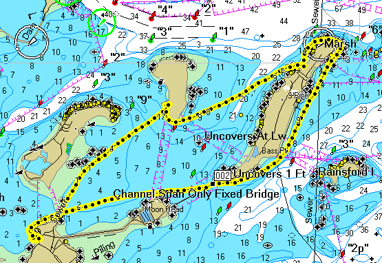
For the uber-nerdy among you, <a href="http://www.wtpaddlers.org/tripstats.html">here is a dump from my GPS of the trip</a>. And below is the breadcrumb map it generated.
I haven't figured out how it determines when to start/end each leg of the trip. I do know that the dots on the map do NOT correspond to the trip legs.
Interesting timeline points:
From 8:00 till 8:28, I was probably just floating around just offshore.
At 8:42, we must have paused to regroup.
Soon after 9:00, we landed at Spectacle and stayed an hour.
At 1:20:43, I was paddling Dave's boat. (I want Dave's boat.)
The dots are just there to indicate the line. If I zoom in close, there are more dots between one spot and the next. i.e., the dots are maybe 20 pixels apart, whether you're zoomed way in or way out.
I can't figure out what the deal is with the altitude. It should have remained constant, right around sea level. I was wondering if it was depth, but that doesn't make a lot of sense either, but maybe...
I can't figure out what the deal is with the altitude. It should have remained constant, right around sea level. I was wondering if it was depth, but that doesn't make a lot of sense either, but maybe...
Dave wrote:I'll download my pics and send them over tonight, before the game.
We should do the bowling thing this winter! Can't wait to ski either. Didn't get up to the mountains this summer. New England really is pretty cool! You know, aside from the natives.
GO SOX!!!
Current Designs Solstice GTS
Placid Boatworks Rapidfire
Placid Boatworks Rapidfire
All this difficulty with technology  .
.
Next time I'll use my stop watch to time the legs of the trip and mount my deck compass to track our bearings so we can figure out our speed the old fashioned way. Plotting our course on the chart, measuring the distance and dividing by the time it took to travel to derive our speed.
BTW - nice pics everyone!
Craig
Hurricane A/S Tracer Yellow/White
Heritage Shearwater - Red/White
Heritage Tandem - Mango
Hurricane A/S Tracer Yellow/White
Heritage Shearwater - Red/White
Heritage Tandem - Mango
chpaton wrote:Next time I'll use my stop watch to time the legs of the trip and mount my deck compass to track our bearings so we can figure out our speed the old fashioned way. Plotting our course on the chart, measuring the distance and dividing by the time it took to travel to derive our speed.
You know, in person, you really don't look very old, but then you start to talk like this...
Navigation
Durnedkids, when I was a boy we had to find our way with a crayon, a protractor, and a compass, and we liked it!
No, really, we did.
No, really, we did.
But in all seriousness... I do plan on getting some decent training in old school navigation. I'm sure it'll come in handy one of these days when I was absolutely SURE that I'd charged the batteries, and absolutely SURE that the weatherman said clear and sunny all day.
However, on these days when I'm really not in the mood to work, it's fun having the GPS data to play with.
However, on these days when I'm really not in the mood to work, it's fun having the GPS data to play with.
Honestly, I don't anticipate finding myself in a position that can't get my bearings from the shore any time soon. I want to get a VHF radio, and between that and the GPS, I can call for help, which is why I wanted one. Perhaps in the fall I can break out the old common task manual and show you guys how to plot your position and call for artillery on an random target, if your interested. (I was an infantry sgt for awhile, I think I remember how to do it.) Once you got that down, you should be pretty much set on being able to figure out where you are and where the thing you want to get to is, (which is all that really means.) Plus, you never know, you may want to call in artillery some time. I'm not real keen on the manual navigation while in the kayak, I still find it a little hard to focus on the map, much less shoot an azimuth while bobbing like a cork. GPS is nice for that.
NorwayLady wrote:Hi guys.
What a day yesterday! You guys really locked out weatherwise. Thanks for sharing all the great photos.
We had a great day too. 6 women lauched from the Driftway. Kayaked out to the Spit and up the South River. Took a quick break in Humarock by Roger's workshop, and continued on almost up to Rexham beach before we turned around and took pretty much the same route home. Don't know the milage, but it sure was a great paddle.
Bea
Bea,
I'm glad you had the chance to get out. You definitely need to join us on a harbor trip.
This has to be a milestone. Turkeys were involved in at least 3 trips in one day. Anyone else?
Current Designs Solstice GTS
Placid Boatworks Rapidfire
Placid Boatworks Rapidfire
Call For Fire
Which actually, I only thought would be a good way to do some navigation because you can cover plotting, azimuths, back azimuths, triangulating, orienting your map and range finding, without me having to get off my butt and set up a land nav course. Actually though, if we ever do decide to take the time to do it, might as well do it right and do some actual orienteering. Scratch the artillery drill, maybe we can just do a little map and compass work.
Which actually, I only thought would be a good way to do some navigation because you can cover plotting, azimuths, back azimuths, triangulating, orienting your map and range finding, without me having to get off my butt and set up a land nav course. Actually though, if we ever do decide to take the time to do it, might as well do it right and do some actual orienteering. Scratch the artillery drill, maybe we can just do a little map and compass work.
Last edited by Dave on Tue Oct 04, 2005 4:20 pm, edited 1 time in total.