A couple of folks have expressed and interest in paddling to some of the senic Boston Harbor Islands.
Tides and weather forecast look good for a mid day paddle on either Sat. the 6th or Sun. the 7th. High tide is about 1:10 PM on Sat. and 1:45 on Sun.
We could:
A. Launch from Nickerson Beach on Squatum an hour or two before high tide and paddle to Thompson's Is and Spectacle Is. in Dorchester Bay. Possible play in the tidal pool on Thompson's and perhaps also visit the lighthouse and abandoned military installation on Long Is. Overall time about 4 hours. Potential challenges: boat wakes from pleasure and commercial traffic, chop & swells depending on wind speed and direction
B. Launch from Wollaston Beach (across from Tony's Clam Shack)an hour or two before high tide paddle straight out to Rainsford Is & return. depending on conditions and time we could also visit Hangman's, Long Is. or Portuguese Cove on Peddok's. Again looking at an overall time of about 4 hours. Maybe a little less challenging than Dorchester Bay alot depends on wind speed and direction.
Anybody interested?
Boston Harbor Islands - Quincy or Dorchester Bay?
Moderator: Chip
Boston Harbor Islands - Quincy or Dorchester Bay?
Craig
Hurricane A/S Tracer Yellow/White
Heritage Shearwater - Red/White
Heritage Tandem - Mango
Hurricane A/S Tracer Yellow/White
Heritage Shearwater - Red/White
Heritage Tandem - Mango

-
getnoutside
- Posts: 751
- Joined: Wed Jun 22, 2005 11:51 am
- Location: Marshfield
- Contact:

 Impex Currituck
-
getnoutside
- Posts: 751
- Joined: Wed Jun 22, 2005 11:51 am
- Location: Marshfield
- Contact:
Cannah make it
I'll be making another Rochester trip this weekend. Sorry I'll miss it, next time though, I'm there! You guys have fun. You should do Quincy, you can finish off the trip with Tony's or mabe a pit stop at the place next door to Tony's.
Enjoy!
Enjoy!
get'n-outside wrote:Chip,
There's no sense in both of us not being able to go. Since you're feeling guilty anyway, how about taking my kids
I said guilty, not INSANE.
Current Designs Solstice GTS
Placid Boatworks Rapidfire
Placid Boatworks Rapidfire
Re: Dorchester or Quincy Bay
Sounds like it might be difficult for alot of folks this weekend. Maybe more notice and a chance for folks to arrange their schedules might be in order.
Doing Dorchester Bay with a flotilla would be fun, so how about looking to do that trip on either August 20 or 21. High Tide is about 12:15 PM on the 20th and 1:10 PM on the 21st - anticipate a launch 1 to 2 hours before high tide (we'll let group consensus determine the actual time) and pick the day based on when the most people are available.
As far as this weekend goes, I intend to paddle either Sat or Sun in Quincy Bay, launching from Wollaston Beach. If anybody is free and wants to try the "run to Rainsford" reply with a post here and we can arrange specifics.
Craig
Hurricane A/S Tracer Yellow/White
Heritage Shearwater - Red/White
Heritage Tandem - Mango
Hurricane A/S Tracer Yellow/White
Heritage Shearwater - Red/White
Heritage Tandem - Mango
I definitely can't make it on the 20/21. I'm hosting a poker tournament. I'll be preparing on the 20th and, er... "recovering" on the 21st.
This weekend would probably be better for me. I think we're going to postpone the Duxbury trip that was going to be on Monday. Nelson will go, and I think a little arm-twisting might work on Chip.
This weekend would probably be better for me. I think we're going to postpone the Duxbury trip that was going to be on Monday. Nelson will go, and I think a little arm-twisting might work on Chip.
Weekend Marine Forecast for Boston Harbor
Here's the weekend Marine Weather for Boston Harbor.
SAT
N WINDS 5 TO 10 KT. WAVES 1 FOOT OR LESS.
SUN
NW WINDS AROUND 5 KT...BECOMING S IN THE AFTERNOON AND
EVENING...THEN BECOMING SW AFTER MIDNIGHT. WAVES 1 FOOT OR LESS.
Northerly winds will be pretty much abeam coming and going. NW will be on the stern quater going out and the bow quarter coming back. Tide current will be pretty much opposing us as it will be coming in as we are going out and going out as we are coming in.
We have 1 vote for Sat. the 6th - any destination preferences?
Craig
Hurricane A/S Tracer Yellow/White
Heritage Shearwater - Red/White
Heritage Tandem - Mango
Hurricane A/S Tracer Yellow/White
Heritage Shearwater - Red/White
Heritage Tandem - Mango
It's been one of those days!
I woke up this morning and surprise surprise - no hot water. We have "tankless hot water" via our oil fired boiler. An every once and a while (especially after a large oil delievery) the sludge in the tank gets stirred up and clogs up the works.
Spent today trying to locate a burner tech to come out and do the work - our regular guy - is retiring and his availability is limited. Hopefully, I'll get this fixed tonite!
BECAUSE - "She, who must be obeyed" will not authorize tomorrow's trip unless she can take a hot shower (All in all, a fairly reasonable request) I need to ensure that the hot water is restored before I can paddle on Saturday. At this point, things look good with the repair scheduled for this evening.
Assuming my oil burner repairl goes according to plan, let's meet tomorrow morning at Nickerson Beach at 11:30 and plan to circumnavigate Thompson's and play in the tidal pool with possible side trips to Spectacle, Long & Moon Head depending on desire, conditions and time. Figure on returning around 3.
Nickerson Beach (Quincy) can be reached from E. Squantum St. via Rt 3 and/or Rt 3A. Follow E. Squantum St. east past the entrance to Marina Bay (at that point you are officially on the Squantum peninsula) at the fork in the road bear left - the seawall and bay will be on your left. Follow the road untill you sea the opening in the fence for the beach. Drop your boat at the beach & take your car about 75 yards up the road (up hill) to the parking area for Squaw Rock Park (I think there are detailed directions to the put in on bskc.org and NSPN.org). If you go too far you will be on the restricted road to Moon Head and the Long Is. bridge.
If for some last minute reason (like the oil burner guy doesn't show up tonite) and I can't make it, I'll post here later this evening and postpone until Sunday.
Nelson: you're the only one who posted a definite interest & availability - if things have changed let me know.
Craig
Hurricane A/S Tracer Yellow/White
Heritage Shearwater - Red/White
Heritage Tandem - Mango
Hurricane A/S Tracer Yellow/White
Heritage Shearwater - Red/White
Heritage Tandem - Mango
Trip Report!
Sorry this is a bit late. But "she who must be obeyed" had some chores for your humble scribe on Sunday!
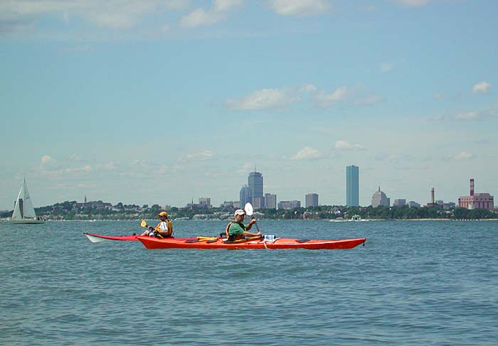
Saturday August 6th, the day dawned with a bit of high haze and a light but building breeze out of the northwest. Pat’s car was road-able, Craig’s hot water had been restored, and Nelson, as ever, was raring to go! We met at the Nickerson Beach put-in on the Squantum peninsula in Quincy on the agreed rendezvous time of 11:30 AM. The haze had burned off giving us clear skis for the planned trip down Dorchester Bay. We decided to pay a visit to the tidal pool on Thompson’s Is. then proceed up the bay to the Western Way channel.
We departed the put-in at about 11:45 AM, Pat in his royal blue Wilderness Systems Tsunami, Nelson aboard his lava/mango P & H Cappella, and Craig atop his red/white Heritage Shearwater. As soon as we left the put-in an turned north east towards Thompson’s we realized that the previous marine forecast for light northerly winds of 5 to 10 mph was a bit conservative. As we headed for Thompson’s the wind was fairly steady at an estimated 10 from the northwest. It would increase and swing northerly, then northeasterly as the day progressed. We proceeded the mile plus to the tidal inlet on Thompson’s without incident.
Unfortunately, the conditions at the inlet were not as challenging as Nelson was hoping for. The combination of tide flowing into the basin and wind in the same general direction added up to no standing waves at the inlet’s mouth. Our pod of kayaks entered and took a brief look around the shallow pond. Craig spotted one great blue heron taking flight disturbed by our intrusion. Climbing structures used for part of the training regimen for the students at the Outward Bound school resident on the island were also seen.
As we were less than an hour from high tide, the incoming current had moderated enough to allow us to paddle out of the inlet against it. We then proceeded up Dorchester Bay towards the Western Way channel separating Thompson’s from Spectacle Is. Along the way we passed the main dock at Thompson’s where Outward Bound students were boarding two of the school’s whale boats for a day of rowing and sailing lessons.
When we reached the Western Way and the tip of Thompson’s, we landed on a beach overlooking the channel. About half a dozen tandem kayaks and two singles were pulled up on the beach. We didn’t see any trace of the paddlers. During our trip up Dorchester Bay the wind had increased to a steady 10 mph and was blowing a bit more from a northerly direction, meaning winds abeam for the paddle up along Thompson’s. Wind waves were increasing to over a foot, and as we got further out into the harbor the remnants of ocean swells were in evidence. Once we had reconnoitered the situation we felt the situation demanded a visit to Spectacle Is. We re-boarded the kayaks and paddled out the third of a mile to the # 9 can marking the edge of the channel. On the way out we enjoyed some boat wakes taken head on. At the # 9 can we closed ranks and paddled briskly across the remaining tenth of mile to the beach.
We spent a bit of time trespassing on Spectacle, enjoying the panoramic vistas and climbing up to the highest point of the Is. which affords a 360º view of the harbor. On the way down we encountered another group of trespassers, on of whom indicated that Spectacle remains closed because of problems with the drainage system and the continued leeching of contaminants from the capped dump into the harbor.
During out sojourn on the Spectacle the winds had built to about 15 mph and were now blowing directly out of the north. We decided to circumnavigate Spectacle in a clock wise fashion and make our return down Sculpin Ledge Channel between Spectacle and Long Is. and Moon Head and Thompson’s.
The trip around Spectacle provided the best “sea kayaking” conditions of the day. The swell was easily 2’ and in a fairly confused state because of the ever present reflections off the rip rap surrounding Spectacle’s shoreline. Wind waves and distant boat wakes added to the fun! Everybody got their bow deep in at least once, with some water coming over on occasion. I’m sure each of us executed a hip twitch or two for stability’s sake. The distance around Spectacle charts out to about just a shade over 2 miles.
Once we completed the circumnavigation, we paused just off the main docks on Spectacle before crossing the Western Way channel and back to Thompson’s. Everyone commented that the channel seemed a lot wider going back than it did coming out. The tide had turned and was fairly strong. We crossed without incident and proceeded down the slot between Thompson’s and Moon Head.
The wind continued to blow at about 15 mph but had continued to shift to the northeast placing it directly on our stern quarter for the return trip. This wind was kicking up a fairly confused state of wind waves – steepened no doubt by the swiftly flowing out going tide. After about a mile we pulled into the beach on Thompson’s for a final stretch of the legs and another photo op. for Pat & Nelson before heading in the final mile around the sand spit and past Chapel Rock and Squaw Rock to the take-out at Nickerson Beach.
We were ashore by 4 PM. A retrace of our route on the chart indicates about 7 and 2/3 miles covered – actual distance paddled was probably closer to 8 miles. After the ‘yaks were loaded we enjoyed a couple of after paddle beers and paddling related conversation at Craig’s house in Quincy. All in all a nice day on the water with some excellent company!
Craig
Hurricane A/S Tracer Yellow/White
Heritage Shearwater - Red/White
Heritage Tandem - Mango
Hurricane A/S Tracer Yellow/White
Heritage Shearwater - Red/White
Heritage Tandem - Mango
Thanks Craig! Trip report has been posted. I'm going to assemble a 360° panorama and add that to the report as soon as I get a chance.
I should mention that Craig is either very good at making stuff up quickly, or he's got an amazing knowledge of Boston Harbor. Nelson and I peppered him with questions all day, and he fielded them all! It should also be noted that he's got exceptionally good taste in beer.
I should mention that Craig is either very good at making stuff up quickly, or he's got an amazing knowledge of Boston Harbor. Nelson and I peppered him with questions all day, and he fielded them all! It should also be noted that he's got exceptionally good taste in beer.
-
getnoutside
- Posts: 751
- Joined: Wed Jun 22, 2005 11:51 am
- Location: Marshfield
- Contact: