
Well, here's how it happened. On Saturday, Sue and I went for a quick paddle on Oldham Pond in Pembroke. So we got a later than usual start getting packing to go to camp for the weekend. Halfway through packing, I remembered that our gas grill down there was out of propane. So I knew I'd have to make a trip to the local propane store down there for a fill.
I called them, and the guy there said that they'd be open for another twenty minutes. I said thanks, but it'd be a good hour before we could drive to camp, get the empty tank, and drive to his place. He said he'd be willing to stay open till we got there. (Wow!) So we quickly finished packing and rushed out. Without my camera. Huge mistake.
That night, sitting around a campfire, Ron Chip and I talked about <a href="http://www.wtpaddlers.org/phpBB2/viewtopic.php?t=82">the Cohasset trip</a> on Monday. The weather was looking to be foul (it's pouring as I type this), and I'd received a PM from Nelson saying that his back was bothering him, and he was a question mark for the trip. This was a big factor, as I know that he's been looking forward to paddling to Minot Light for a long time. So I made a third-beer executive decision and bagged the trip right there.
We then decided to take a little impromptu trip out on Plymouth Harbor the following morning. Maybe straight out to Long Beach, and perhaps around the horn and see if there was any action on the ocean side of the peninsula. High tide was at 7:00, so we needed to get an early start. We agreed to meet at 7:30 to load up the boats. Based on this, we ended the fire and headed back to our campsites at the ludicrously early hour of 1:00 am.
We got to Nelson Beach a little after 8:00. At that point, I realized how critical a mistake it was to forget my camera. The air was brilliantly clear. Saquish and Clarkes Island, normally dark bumps on the horizon, were clear enough that you could make out the windows on the houses.
We launched and made a bee line for the tip of Long Beach. At that time of the morning on a Sunday, all of the wacko boaters were still in bed nursing hangovers, so it was a fairly uneventful trip.
After landing on Long Beach, we walked to the ocean side to check the score. Not much happening. From our vantage point, it didn't look any more exciting than the bay side. So we looked north.
Clarks and Saquish were clearer than ever, and awfully inviting. However, the tide was going out, and we'd heard horror stories of heavy currents in the channel. The lighthouse seemed like halfway across, and perhaps a good destination. If the current started becoming a concern, we could turn around.
But although we did notice the effect of the current a few times during the trip, it was never really a problem. We made it to the lighthouse in short order and had a chance to check it out close up. This was truly "Cormorant Central", and Ron noted that the solar panels up there probably weren't as efficient as they could be, as they had a thick covering of cormorant "gifts".
But look at Clarks over there! You could almost reach out and touch it. We didn't see the point in coming so close to it and not making the trip. So off we went. The chop was a little more interesting on this leg, but nothing we hadn't seen before.
The beach on the southern end of Clarks is very very rocky, and we were lucky to find a tiny blotch of sand just big enough for three kayaks. We landed there and had an extended rest with a snack. Now we had to decide what to do at this point. We'd traveled 3.5 miles. In the past, we'd found that a 7-mile trip was about as much as we liked to do, and we were pretty tired at the end of it.
Chip's GPS indicated that Clarks was about as long as our initial trip from Nelson Beach to Long Island. This seemed an awful lot bigger than we all remembered from maps, so we decided to circumnavigate the island. It seemed foolish to come all this way and not see the island. So we set off to see what Clarks had to offer.
In all honesty, it didn't have much. From our vantage point, it really looked like a small suburb of Nantucket. Nicely manicured lawns, very quiet, very serene, and quaint little signs saying "trespassers will be disemboweled". (Well, the signs <i>actually</i> just said "No Trespassing".) It was clear that they don't appreciate unnanounced visitors.
So our next rest stop was after crossing a short channel and landing on the tip of Saquish.
We decided that on our return trip, we'd skip the lighthouse halfway point and head directly for Long Beach. The boat activity had picked up considerably, and we knew that this stretch was going to be interesting.
YOWZA!!
That was some exciting paddling! Once we got out toward the middle and were in the main shipping channel, we saw waves like we'd never seen before. Off to my left, I heard "wham-splash", and I wondered what that was. But not for long, because the bow of my boat went wham-splash! Lots of water over the bow, and a considerable amount hitting the spray skirts. We'd have swamped without them.
Throughout the middle of the channel, we <i>were</i> a little lucky with boats. None of the behemoths came through, and very little boat traffic at all passed by. I was a little nervous when we were getting soundly tossed around and I could see that we we still had white caps in front of us to get through. But they turned out to be no worse than what we'd been through.
We went through an area that was slightly calmer, and we figured that maybe we were out of the worst of it. But perhaps this was the very center of the channel where the boat wake was at a minimum, because not long after that, we were back into the thick of it again. Only this time, the boat activity picked up, and along with the waves, we had to watch out for powerboats coming in all directions. Now that they were out of the harbor, most of the smaller boats had no need to keep within the channel markers. "We don' need no steenking buoys!!!"
But we made it to the beach in one piece, and with surprisingly clean shorts. We spent a little time on the beach resting, talking about the event, and pulling our eyebrows back down our foreheads.
The day would have been absolutely perfect if our cars were parked there. But now we had that last leg across the harbor, over a mile, to get back to Nelson Beach. We were tired, the water wasn't interesting, and best of all, it started getting shallow. Real shallow. That friggin' low tide.
I poled my way across much of it. Chip dealt with the familiar sand flats decision: "Row v. Wade", and decided to hoof it, pulling his yak behind. We soldiered on the rest of the way and landed on a beach that was now about a mile wide itself. Chip and Ron carried their boats up to the cars. I had my trusty wheeled carrier, which I couldn't assemble to save my life. I finally got it together and pulled my yak through the mud and rocks up to the cars.
For a last minute impromptu trip, that was one HELL of a ride!
Plymouth Harbor -> Long Beach -> Clarks Island - 9/28
Moderator: Chip
 Impex Currituck

Good thing the weather sucks because my back is feeling better and I wouldn't have been too happy to miss the Cohassett trip.
I know you guys don't have internet down at the camp but the phones still work..... right??
Sounded like an exciting trip (up until the end). Let me know when you want to do it again.
I know you guys don't have internet down at the camp but the phones still work..... right??
Sounded like an exciting trip (up until the end). Let me know when you want to do it again.
P&H Quest LV - Yellow/white/blue

Sorry Nelson,
I knew you would have liked it. It was a last minute decision to even go. Finalized at probably 10 or 11pm. Also, the thought was to paddle to long beach and maybe play in the harbor wake. Had we known how it would end, we certainly would have made more of an effort to include everyone.
I knew you would have liked it. It was a last minute decision to even go. Finalized at probably 10 or 11pm. Also, the thought was to paddle to long beach and maybe play in the harbor wake. Had we known how it would end, we certainly would have made more of an effort to include everyone.
Current Designs Solstice GTS
Placid Boatworks Rapidfire
Placid Boatworks Rapidfire
Thanks Chip,
I understand about your trip, you do have to be spontaneous sometimes. However, I would have liked a call letting me know the Cohassett trip was cancelled. I was checking the forum up until 11 last night, made a couple of phone calls (got voicemail only) and set my alarm for the morning to see what was going on. At 6:15 still nothing on the forum and heard the rain so I assumed it was cancelled. Didn't find out for sure until 8pm.
Too bad you guys didn't have a camera on your trip. I would have liked to have seen some Gurnet Light pics.
P&H Quest LV - Yellow/white/blue
Birdseye wrote:However, I would have liked a call letting me know the Cohassett trip was cancelled. I was checking the forum up until 11 last night, made a couple of phone calls (got voicemail only) and set my alarm for the morning to see what was going on. At 6:15 still nothing on the forum and heard the rain so I assumed it was cancelled. Didn't find out for sure until 8pm.
Sorry - that was my fault. We got home a little late, and there's a crisis on the Marshfield forum that I had to tend to.
Too bad you guys didn't have a camera on your trip. I would have liked to have seen some Gurnet Light pics.
I just read this report again and realized that you guys were talking about Bug Light... right, not Gurnet Light.
I'd still like to get out to Gurnet one of these days.
P&H Quest LV - Yellow/white/blue
-
getnoutside
- Posts: 751
- Joined: Wed Jun 22, 2005 11:51 am
- Location: Marshfield
- Contact:
Birdseye wrote:Too bad you guys didn't have a camera on your trip. I would have liked to have seen some Gurnet Light pics.
I just read this report again and realized that you guys were talking about Bug Light... right, not Gurnet Light.
I'd still like to get out to Gurnet one of these days.
You weren't far off
 [/img]
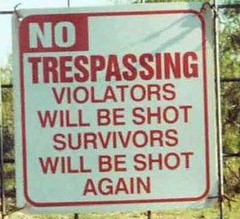

 P&H Cetus HV
 The leg of the trip between the tip of Long Beach and the launch at Nelson Beach sucks hard. If you hit it towards low tide, you're likely to be walking over the flats towing your boat. And Nelson Beach spans two zip codes. It's a nasty trip to carry a boat when you're already tired.
On the ocean side of Long beach, not too far from the tip, it appears that vehicles are still allowed to drive. It might be a much more enjoyable trip if we could launch from THERE, cross to Saquish, and then up to Gurnet. It would be only 6 miles, rather than 9.
On the ocean side of Long beach, not too far from the tip, it appears that vehicles are still allowed to drive. It might be a much more enjoyable trip if we could launch from THERE, cross to Saquish, and then up to Gurnet. It would be only 6 miles, rather than 9.
pat wrote:The leg of the trip between the tip of Long Beach and the launch at Nelson Beach sucks hard. If you hit it towards low tide, you're likely to be walking over the flats towing your boat. And Nelson Beach spans two zip codes. It's a nasty trip to carry a boat when you're already tired.
On the ocean side of Long beach, not too far from the tip, it appears that vehicles are still allowed to drive. It might be a much more enjoyable trip if we could launch from THERE, cross to Saquish, and then up to Gurnet. It would be only 6 miles, rather than 9.
You need to be a resident to get a sticker to drive out there.
Current Designs Solstice GTS
Placid Boatworks Rapidfire
Placid Boatworks Rapidfire
How about launching from Duxbury with the outgoing tide and returning with the incoming tide. This is one of the launches the Boston Sea Kayakers Club uses to get out to Gurnet Light.
Duxbury, Howlands Landing (Just west of Myles Standish monument)
Rte 3 exit 10 (S. Duxbury) Travel on 3A north 2 miles right onto Chestnut Street, 1 mile to Hall's Corner. At the flagpole, 2nd right onto Standish Street - 1/2 mile turn right at Crescent St (tennis court) 1/2 mile turn right at Howland's Landing. No facilities, but good water even at low tide.
P&H Quest LV - Yellow/white/blue
-
getnoutside
- Posts: 751
- Joined: Wed Jun 22, 2005 11:51 am
- Location: Marshfield
- Contact:
Birdseye wrote:How about launching from Duxbury with the outgoing tide and returning with the incoming tide. This is one of the launches the Boston Sea Kayakers Club uses to get out to Gurnet Light.
Duxbury, Howlands Landing (Just west of Myles Standish monument)
Rte 3 exit 10 (S. Duxbury) Travel on 3A north 2 miles right onto Chestnut Street, 1 mile to Hall's Corner. At the flagpole, 2nd right onto Standish Street - 1/2 mile turn right at Crescent St (tennis court) 1/2 mile turn right at Howland's Landing. No facilities, but good water even at low tide.
I've launched from there. Would be better on a weekday since parking is limited. There's a nice beach on the ocean side of Standish Point.
It's also a good place to launch if you want to explore the Jones River.
Birdseye wrote:How about launching from Duxbury with the outgoing tide and returning with the incoming tide. This is one of the launches the Boston Sea Kayakers Club uses to get out to Gurnet Light.
Duxbury, Howlands Landing (Just west of Myles Standish monument)
Rte 3 exit 10 (S. Duxbury) Travel on 3A north 2 miles right onto Chestnut Street, 1 mile to Hall's Corner. At the flagpole, 2nd right onto Standish Street - 1/2 mile turn right at Crescent St (tennis court) 1/2 mile turn right at Howland's Landing. No facilities, but good water even at low tide.
I don't have a map. Does that save any distance as opposed to Nelson Beach?
Current Designs Solstice GTS
Placid Boatworks Rapidfire
Placid Boatworks Rapidfire
I'm up for 10 miles.
Here's another put-in in Duxbury:
Duxbury, Harden’s Hill Rd.
Take Route 3 to Exit 10. Follow 3A north one mile to Bailey's Corner and turn right on Chestnut St. Follow this to its end at Halls Corner (approximately 1/3 mile). Bear left on Washington St (Not a hard left - that is Depot St). Take the first right off Washington St onto Harden Hill Road. Proceed down the hill to the end at the launch ramp. Limited parking.
P&H Quest LV - Yellow/white/blue